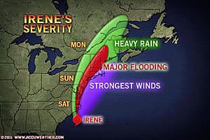

While Irene is not forecast to track as far west, nor as fast, as Hazel did in 1954, it will ride up along the mid-Atlantic coast in such a way as to inflict major damage in many coastal and some inland communities. In today’s dollars, Hazel was a multi-billion-dollar storm and reached Category 4 at peak intensity.
Irene will track farther east than Hazel, and farther west than Bob (1991). Meteorologist Heather Buchman compares Irene to storms in the past.
While Irene is expected to weaken Saturday into Sunday after encountering cooler waters in northern latitudes, that will not happen fast enough to prevent serious problems from wind, rain a nd ocean water.
If you live near the projected path of Irene, you are at risk for power outages, flooding problems and property damage with this storm.
Power Outages
Downed trees alone have potential to block many streets and secondary roads from eastern North Carolina northward to southeastern Quebec, running along the very heavily populated I-95 Northeast U.S. corridor.
With saturated soil, water-logged, heavy trees will topple and break, as will tree limbs.
When trees come down, they take power lines with them. There could be millions in the dark for hours and hundreds of thousands without power for days starting at the height of Irene, and in her wake.
Some people could be without tap water as a result of the power being out.
Flooding Rainfall
Irene will bring serious flooding from heavy rain in the coastal mid-Atlantic and portions of New England. It is not a question, not a risk; it is a certainty.
Many areas in the Northeast have been hit with record or near-record rainfall for the month of August, and a few are flirting with their wettest month ever. Rain from thunderstorms in advance of Irene will make matters worse.
The saturated state of the ground will mean that water has nowhere to go but into yards, streets, streams and rivers.
The worst conditions will be in the stretch from the Delmarva northward through New Jersey, western New England and the Hudson Valley of New York. In part of this area, a foot of rain could fall over a 24- to 48-hour period.
Coastal Flooding, Beach Erosion
Serious coastal flooding and beach erosion are expected from North Carolina northward to Maine.
In a specific sense, the exact degree of above-normal tides is tricky and highly variable due to the highly varied shapes of the coast, barrier islands and back bays.
In a general sense, tides will average 2 to 4 feet above normal, but locally higher surge is likely with wave action on top of the mean level of the sea and open bays.
If you get coastal flooding during a strong nor’easter, you will likely get flooding with Irene. Some barrier islands may be cut off for a time.
Some beaches and boardwalks in the mid-Atlantic and southern New England could sustain damage so severe that they are un-repairable for the duration of the 2011 summer season.
High Winds
Many people along the Atlantic Seaboard probably have not experienced such a strong storm as we expect with Hurricane Irene. People in the path of Irene should stay indoors during the height of this storm.
Some of the youngest of the crowd were not around for Floyd (1999), Fran (1996), Gloria (1985) and others. Then there are the storms of the more distant generations of the 1960s and 1950s, which include Donna (1960), Diane (1955) and Hazel (1954).
In addition to the potential for a great number of downed trees and power lines, Irene can cause other property issues ranging from damaged roofs and siding to busted windows. These items, and others knocked loose, will become airborne projectiles.
High winds will affect air travel and high-profile vehicles in the path of Irene.
There are many bridges that reach sky-high in the major port cities. The higher up you are, the stronger the winds will be. Travel over these bridges for a time at the height of Irene could be halted.
We can only hope that people heed warnings and get out of harm’s way in advance of Irene.
Keep checking in at www.AccuWeather.com as there may be further adjustments to Irene’s path in the north, as the two-way impact between the hurricane and other weather systems becomes clearer.
The impacts on lives, property, commerce and travel will be serious.
While Irene is not forecast to track as far west, nor as fast, as Hazel did in 1954, it will ride up along the mid-Atlantic coast in such a way as to inflict major damage in many coastal and some inland communities. In today’s dollars, Hazel was a multi-billion-dollar storm and reached Category 4 at peak intensity.
Irene will track farther east than Hazel, and farther west than Bob (1991). Meteorologist Heather Buchman compares Irene to storms in the past.
While Irene is expected to weaken Saturday into Sunday after encountering cooler waters in northern latitudes, that will not happen fast enough to prevent serious problems from wind, rain a
By Alex Sosnowski, Expert Senior Meteorologist for AccuWeather.com
Photo: www.ccuWeather.com.
